PanGazer – image geography
Image files can include ‘metadata’ (extra information, such as camera settings and location) as well as the image itself. PanGazer emphasises and simplifies the viewing and editing of the camera’s geographical metadata values (it’s position in space), including:
- the location (latitude and longitude) of the camera
- the elevation (metres or feet above sea level) of the camera
- the compass bearing of the camera (the azimuth of the centre of the image, from True North)
- the tilt of the camera (the tilt of the centre of the image, relative to the horizon) – this is always 0° for a spherical image.
If available, these values are shown as ‘static’ status at bottom-right of the view (except for a tilt of 0°). See the screenshot below and the General settings page for details.
In addition, if the bearing is known then compass points (and a North line) can be overlaid on the image to help give a sense of direction, and, similarly, if the tilt is known then tilt angles can be overlaid. Again, see the screenshot below, and the Overlays page for details.
The geographical values can be edited by selecting Image → Change image geography (or pressing the ‘g’ key) which will open a dialog (described in detail below) that lets you view, modify, add, or delete relevant values for the image being viewed. In addition, the bearing can be set quickly for 360° images or spherical panoramas by using the Set North option on the pop-up menu (see the Setting North page for details) and similarly Set horizon can be used to set the horizon for non-spherical images.
The geographical values for an image are held in the Exchangeable image file (Exif) metadata associated with an image; if you make any changes to the values you will be prompted to save the image before it is replaced or PanGazer is closed. Geographical values from XMP metadata, if available, will be used where Exif metadata are missing (e.g., if the compass bearing is in XMP metadata but not in Exif metadata then the XMP value is used unless the XMP value was default and written by PanGazer). When you save a spherical image the geographical data are also copied to XMP metadata.
Image geography dialog
The Image geography dialog is used to view, modify, add, or delete geographical values for the image being viewed. It is especially useful for adding missing values or adjusting existing values. GPS location values can be inaccurate in rugged terrain or in urban situations, elevations are usually far less accurate than location data, and the camera bearing and tilt of the image are often not available.
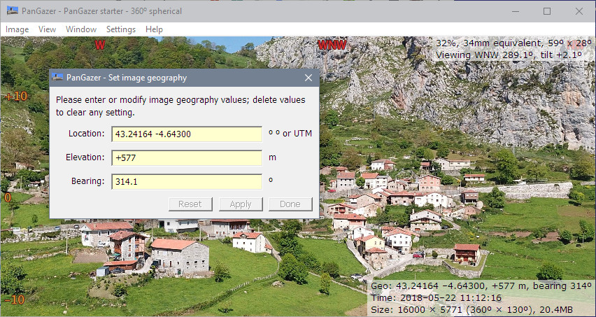
To open the Image geography dialog, select the Image → Change image geography menu item or press the ‘g’ key. This will open the dialog and present the geographical values, for example:
You can edit any of the values directly; to delete a value clear the entry field (delete all the characters in it).
If you change or delete any value the Apply and Done buttons will be enabled (if all the values are good); the image will not be affected until you click one of those. To leave the dialog without applying changes, close it using its system menu or clicking the ‘X’. If any change has been made you can also reset the values to the initial values (the values when the dialog was opened) by clicking on the Reset button.
The geographical values shown are:
Location: The image latitude and longitude. If the image location is known it will be shown here, formatted using the Coordinates format setting in effect when the dialog was opened. You can then modify the location as required. Many input formats are accepted, including UTM format; for details, see the Coordinate formats page.
Elevation: The elevation of of the camera in metres or feet above or below mean sea level. The units used in the dialog box are those first listed under Settings → Measurement settings (see the General settings page for details) when the dialog was opened; both metres and feet will be displayed in a view’s status if requested.
Bearing: The bearing (azimuth) of the image; that is, the true compass direction of the centre of the image. You can enter values from −360 through +360 degrees; PanGazer will normalize these to the range 0 through +360 degrees when displaying or saving.
While adjusting the bearing of an image, compass points and a North line (if visible) can be overlaid on the image using the Settings → Overlays → Show compass points and/or → Show North line settings.
Tilt: The tilt of the image; that is the vertical angle of the centre of the image relative to the horizon (positive is above the horizon). You can enter values from −90 through +90 degrees.
While adjusting the tilt of an image, tilt values can be overlaid on the image using the Settings → Overlays → Show tilt angles setting.
Note: the tilt value is neither shown nor editable for spherical images because they always have a calculated horizon with the bottom edge of the image being at −90 degrees and so the tilt is always zero.
Notes:
- There can only be one Image Geography dialog, and it affects only the image that was being viewed when it was opened. If you change to a view of another image the Image Geography dialog still affects only the image that was being viewed when it was opened.
- Earlier versions of PanGazer turned on the Compass points, North line, and Tilt angles overlays while the Image Geography dialog was active; however this was confusing as it appeared the settings could not be changed at that point.
