Requires: GPS
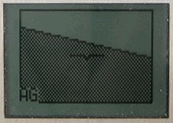
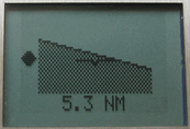
This application has not been tested in flight yet, but the screen shot demonstrates the principle. The intention is to meet the need for a scenario proposed by Kev Armstrong » in which a pilot accidentally flies into a cloud and wants to get back out as quickly and safely as possible. The idea is that the device records recent positions, and when the pilot presses the ‘Backtrack’ button (or starts the application) the device notes the position that the aircraft was at (say) 5 minutes previously, saves this as the target point, and from then on displays something like the pictured image. This has:
- the bank angle (pseudo attitude) in the centre shown as an artificial horizon (the image also shows pitch information, from accelerometer)
- the direction to the target (in this image the target is to the left, indicated as a black diamond at about 9 o’clock – with a bigger screen one could do a nicer arrow, etc.)
- the distance to the target (so you’ll know that you should be out of the cloud when the target is straight ahead and close.
Theory & practice
This application has not been fully coded, or tested, yet, but is a straightforward extension of the other applications. The central part of the screen uses the existing Pilot assist display. The direction and distance to the target point are easily calculated (the algorithms are already used in the Track assist application).This application is really just a specific case of ‘backtrack all the way home’, where the device could always show you a target a few minutes ahead (recorded from the outbound flight) that you could follow. By following the outbound track one would avoid any airspace incursions that a ‘direct line to home’ might incur – so this could make the application a bit more useful than just a “get out of cloud free” card.
