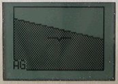
Requires: GPS
This is an experimental and possibly novel application. It is intended to allow the use of a GPS device to guide one’s flight without the need to set waypoints in advance. This turns out to be especially useful when flying without a particular destination or flight plan in mind.
The application, once selected, notes the aircraft’s ground track and altitude. Once the pilot is happy with these, he or she presses a single button, and thereafter the application displays any deviation from that track and altitude.
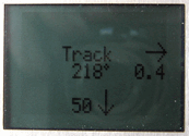
Currently the deviation is shown on the display: in the picture shown, the display indicates that the desired track and altitude is 0.4 NM to the right and 50′ below. The current course is 218°.
Possible enhancements to this application would be:
- flash the red LED if the deviation exceeds various limits
- use the audio output capability of the device to give verbal warnings of deviation (into a suitable headset/intercom) – hence allowing the pilot to spend more time looking outside the aeroplane instead of at the instruments.
Since this photograph was taken, the bearing shown in the centre of the display has been changed to show the divergence/convergence angle compared to the desired track (i.e., showing 0° if flying parallel to the track).
Theory & practice
This application first shows the current bearing; this does not use the GPS device’s reported instantaneous bearing (which proved to be somewhat ‘glitchy’), but instead calculates the bearing from two GPS positions taken 1 and 2 seconds apart (both are shown for interest – only one need be shown). The pilot is invited to press the joystick when happy with the track and current altitude.
At that point the directional display is shown (showing ‘On track’ at that point). As the aircraft diverges from the chosen track a left or right arrow shows which way to turn to rejoin the track, with the distance in NM below. Again, this is calculated from the GPS positional fix, using the starting position and initial bearing saved. Similarly, altitude changes trigger an up or down arrow and the difference in altitude is shown (rounded to 50′).
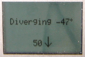
Since the display simply shows distance to the track, conceivably it could give very misleading information is the aircraft were turned around – the pilot could then be following the track in the wrong direction. After some experiments I added a divergence calculation (showing whether the aircraft is flying parallel to the track or diverging to the left or right of it). If diverging more than 45° this is highlighted (and the left/right arrow is no longer shown), as in the picture to the right; if heading in the wrong direction (i.e., diverging more than 90°) a “U-turn needed” message is displayed.
Note that if the ground speed is less than ten knots the track cannot be calculated accurately enough in 2 seconds, so the application does not offer to set a track in this case.

